Tuesday, July 19, 2016

Lake Isabel Natural Slides

For a few years friends at church have invited us to hike to a natural water slide by Lake Isabel.  They usually do this on Memorial Day and I always have to work so we decided that this year we were going to pick a Saturday and do the hike on our own.  So we picked our Saturday, did some research, and headed up to the start of the hike.  We had a hard time finding a really good description of the hike so this post will not only share our experience at a really fun place close to us, it will also give a more detailed description of the entire hike with pictures!

Each way the hike is just short of a mile.  With the five boys (9, 7, 4, 3, and 1) it took us about 45 minutes each way.  The hike starts on the north side of the dam of Lake Isabel.  You park on the west side of the road next to the cars parked for fishing.  There is not marker or sign for the start of the trail so you have to look for it on the east side of the road.  The start of the trail follows the spill way from the dam down. This part is pretty steep but doable for children (our 3 year old made it down just fine).

You can see the trail as you look over the edge of the road.  It heads straight down next to the spillway.


At the bottom of the spill way you cross a small stream then you are able to look back up towards the spillway.


The trail continues to be very well marked and you will come to a fork, either path will take you to the falls.  The one to the left just puts you walking closer to the river, the one to the left has you walk through an aspen grove.  There are a few times when the path splits.  We found in every case, it always came back together to the one trail.


Once through the aspen grove you come to your first climb up and over a small hill.  There are a few of these types of climbs up and over on the hike.  Hanni was a trooper carrying our youngest on her belly the whole way there an back.


The trail is very well defined as you go up and over another little climb.  Here are the boys climbing up.  On this one I did need to support our 4 year old so he wouldn't slide down.


The trail now goes back through a forested area.  You can see how well defined the trail really is.


You will come across a really cool camping area with a fire pit.


Again the trail takes you up and over another little hill.


After coming down from this one you come up to a cool little waterfall.


After this you really follow the river closely.  A few times during the next part of the hike you can choose to walk down in the river or hike up on the rock.  It was a little slippery so I chose to carry my three and four year old as I walked through the water.  


Next you start walking right on the rock, it's slippery so be careful but doable to children.


After coming up over the little climb here you descend again back towards the river.  At this point you are almost there!


We arrived!  


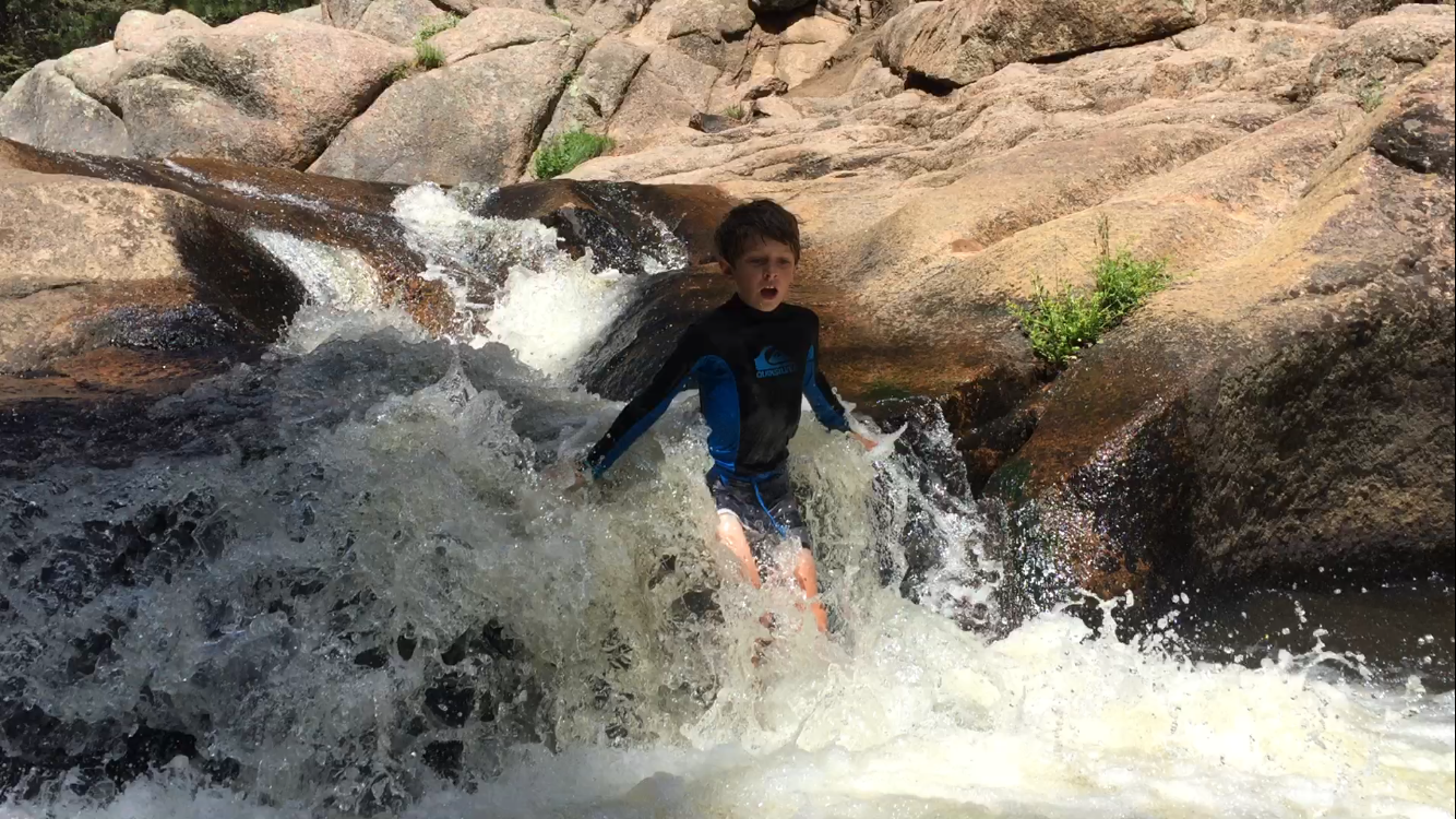
You start the slide right in the water next to my son with the blue shirt on.  Push yourself forward then gravity, the water flow and the slippery rocks do the rest!  You finish in water about waist deep (around 36" for me).

We had an absolute blast going down the slides.  Finn and Tiig both went down on their own.  


I had to show them first that you wouldn't die so I made a little video.  It's a bit chilly when you first hit the water.


Here is Tiig on his first attempt.


I took Kell and Rees on my lap each separate.  Kell was a little apprehensive so I took Rees first and everything went great.  I lifted him up as we dropped into the last part.  This convinced Kell that he would be fine.  So Kell and I started down.  For some reason the first drop knocked Kell and I sideways, Kell almost nailed his head against the rock, then I couldn't get us to sit straight up so we poured over the final part on our sides and both were totally submerged.  Kell was not super stoked about this run.  Makes for a good story though!


Just a few fun pictures from the hike.


Luuk fell asleep on the hike back so Hanni had to hold his head like this the entire way.  She was not such a fan of this.


We had such a blast playing in a super cool natural slide that was so close to home.  Hopefully this helps anyone else who wants to find this fun local place.


Sunday, July 3, 2016

An Epic Adventure

A few friends of mine, Karl and Amy, are planning to hike Mt. Rainier in July.  We planned a training trip months ago to help them know what hiking at elevation would feel like and how their bodies would handle a long day of hiking.  Initially, our plan was to hike Democrat, Lincoln, and Bross but as the trip drew nearer, we decided to hike the 14,433ft Mt. Elbert.  It is the second highest peak in the lower 48 states and slightly higher than the 14,411ft Mt. Rainier.  I wanted to best simulate their summit day on Rainier so we decided to leave Pueblo around 1030pm to start our ascent at 230am.  My oldest Finn really wanted to go but I was concerned about his ability to hike on little sleep.  I found out later in the day that this should not have been a concern!  The drive up was uneventful, lots of talking about gear and my experience on Rainier in 2014.  We made it to the trailhead at 2am and began to gear up for our summit bid.

Initially, the trail to Mt. Elbert is very tame.  Not a lot of elevation gain as you follow the Colorado Trail.  We hiked by headlamp through the forest as the trail slowly increased in elevation.  You leave the Colorado trail and that is where things get steep.  I didn't take any pictures in the early morning hours of our hike because we were making really good time.  We made it to treeline just as the morning light was shining.  I pointed up to what I thought was the summit and said "There's the summit!"  I was wrong.  The trail to the summit has about 3-5 false summits as you climb, this was just the first of many moments when you felt you had reached the top when in reality you had much longer to hike.  

Once above treeline, the trail really starts to pickup some elevation gain.  We stopped much more frequently to rest and regroup.  Karl and Amy were really beginning to feel the effects of climbing at elevation, on no sleep, and after coming straight from sea level the night before.  The climb from treeline to 13,000ft seemed to take hours.  At one of our rest stops, I took the first photo of our adventure.


Here's Finn resting around 13,000ft.  The conditions were much colder than we thought so we were wearing every layer we had throughout most of the hike above treeline.


As we continued hiking after this rest stop Finn was pretty tired.  I could tell that the excitement of the summit was wearing off.  I decided to ask him about the books he has read recently and this is exactly what he needed to take his mind off the lack of sleep and quick elevation gain.  From 13,000ft to 13,700ft he hiked almost continuously as he told me about the two most recent books that he read.  Up until this point we hiked close to Karl and Amy but Finn was in such a zone climbing I didn't want to stop him.  Before we knew it we were above 14k and closing in on another false summit.  When we reached the top of this false summit we were both a little frustrated but we could see that we were on the final ridge to the summit so we quickly regained our energy and continued hiking.  Finn and I reached the summit just after 8am after hiking for 5.5 hours.  We were ecstatic and tired!  It was windy and cold at the summit but we found a good place outside of the wind to rest and wait for our friends to summit.  I told Finn that I wanted to look down the summit ridge to wait for them as he rested in our wind-block.  When I came back a few minutes later to check on him he had fallen asleep!


Finn fast asleep at the top of Colorado.


Karl and Amy made it to the summit ridge just before 9am and the summit right at 9am.


The final push!


Finn and I at the summit!  So proud of him for making it to the top.


Some shots of the summit.


I was also very impressed with Karl and Amy.  They flew in Friday afternoon from sea level, drove down to Pueblo, we left for the trailhead at 10:30pm, started hiking at 2:30am and were at the highest point of Colorado by 9am.  That's impressive.  

Around 930am we started our decent back to the car.  This is usually the longest part of the day because you are tired and just want to sit and relax.  We stayed together for most of the descent, until one point when Finn was in the zone again and didn't want to stop, towards the end of the hike.


Finn, Karl, and Amy working their way down the mountain.


One reason I like early morning starts is to avoid the traffic going up.  These hikers were all on their way up as we were going down.


It's hard to see really how steep it is but some parts of the climb are quite steep.


Descending below tree line.  You can't tell from this picture but we were pretty exhausted and pretty miserable at this point.


My hiking buddy finishing strong.


Finn and I made it back to the car at 1pm after 10.5 hours of hiking.  Karl and Amy were not far behind.  We were spent!  The drive back was pretty quiet but we did have to make our traditional stop at K's Dairy Delite.  Any time we are in Buena Vista this is a must stop.  Some of the best burgers in the state and the shakes are pretty fantastic as well.

All in all it was a fantastic hike.  We made it back to the car safely, exhausted but feeling happy of our accomplishment.  Karl and Amy experienced a portion of what their Rainier hike will be like in July.  They both did very well and I'm sure they will crush their Rainier ascent in July!